Earlier this year, Evan wrote about the gap between deforestation-free and forest-positive. The argument was that companies can verify every plot in their supply chain source from a jurisdiction where net forest carbon is declining. That the supply chain conversation and the landscape conversation need shared measurement to connect them. That satellite-based biomass data - tracking forest carbon year over year, going back 25 years - is the bridge.
We agree with all of that. And we want to push it further.
Because there is a second measurement gap, just as consequential as the first, that the current conversation barely touches. It is this: a forest can have stable canopy cover, accumulating biomass, and increasing carbon stock, and still be in ecological decline. This is not a corner case. In the Atlantic Forest of Brazil, the loss of the large animals that disperse high-carbon hardwood trees has been shown to lower a forest's future carbon storage: starved of dispersers, those trees stop regenerating and are slowly replaced by lower-carbon species. Today's biomass can still be read as healthy, because the loss shows up first in what the forest is regenerating and only later in the carbon it holds.[1] The decline shows up in what a forest is made of long before it shows up in how much of it there is.
The gap satellites can’t see
Remote sensing has transformed how we understand forests at scale. Annual biomass map sat 30-metre resolution, back cast to 2000. Sub-annual loss detection. Disturbance attribution that distinguishes fire from harvest. Twenty-five years of continuous trajectory data that can separate a plantation on a harvest cycle from intact forest gaining biomass steadily, and that can detect degradation years before it becomes visible as canopy loss. This is genuinely powerful infrastructure, and it is what makes landscape-level carbon accounting possible.
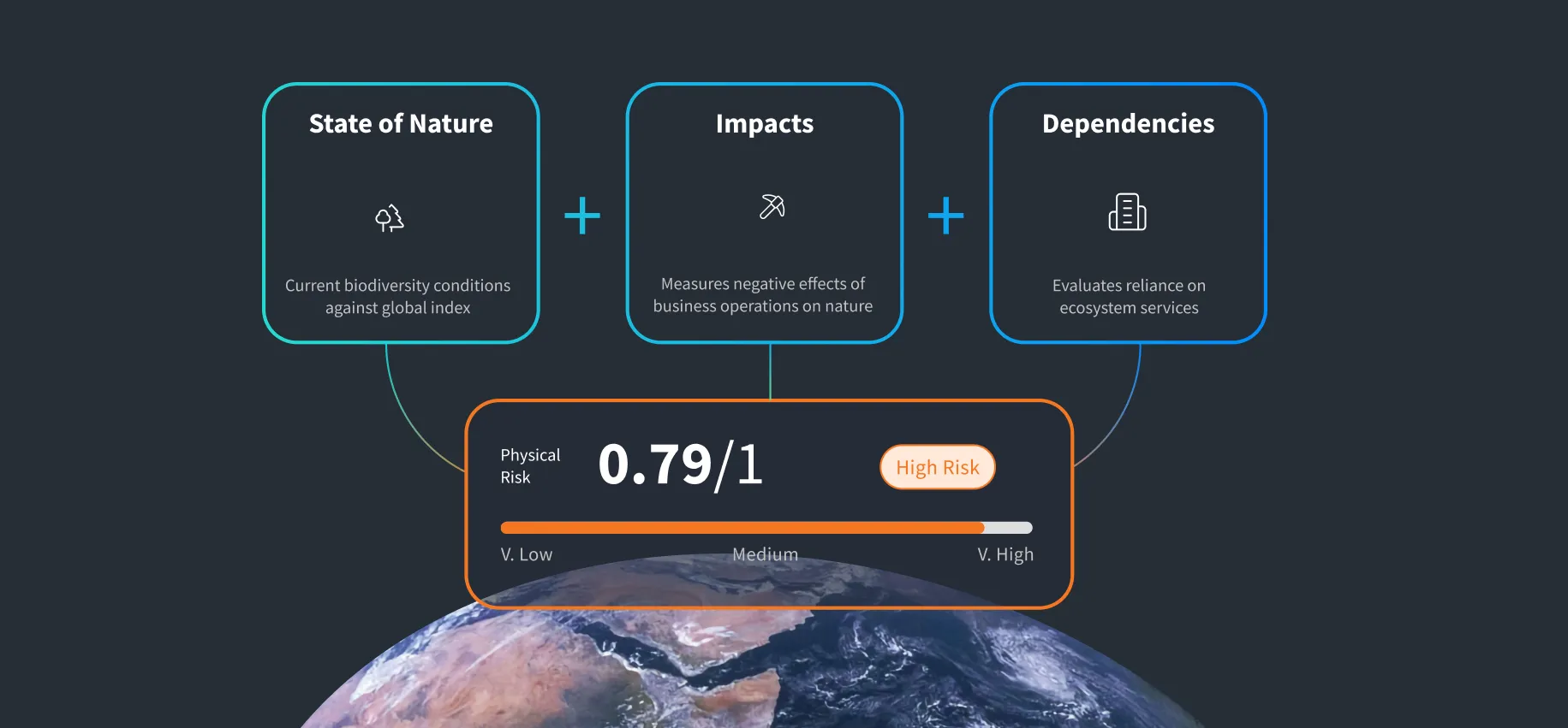
But biomass and canopy cover measure two of the three dimensions of forest condition: Structure (how the landscape is organised spatially) and Function (how productively the ecosystem operates and cycles carbon). They do not measure the third, which is Composition: which species are present, in what diversity, and whether the biological communities that make a forest a functioning ecosystem are intact, simplified, or collapsing.
Consider two restoration areas with the same rising biomass curve on a carbon map. One is rebuilding a functional ecosystem: native species, returning soil life, a regenerating understory. The other is a few fast-growing species accumulating wood and little else. On biomass alone they score the same. Structure and trajectory are what satellites read well. Whether a forest is actually functioning is the part conventional carbon metrics miss.
This matters because the things we are trying to manage (carbon stability, water security, nature recovery) depend on all three dimensions. And the dependency runs in both directions. Without biological monitoring, you cannot know whether a forest's carbon stock is durable. Without remote sensing at scale, you cannot know whether biological recovery at sampled sites is translating into measurable landscape-level outcomes.
A forest's carbon stock is only as durable as its ecological condition. A forest where seed dispersers have disappeared, where mycorrhizal networks have simplified, where pollinator communities have collapsed, is a forest whose long-term carbon storage is at risk, even if today's biomass maps look healthy. The water services that forests provide (catchment regulation, filtration, baseflow maintenance) depend on the biological communities in the soil and streams beneath the canopy, not just the canopy itself.
The nexus is not a diagram. It is a measurement challenge
The climate-water-nature nexus has become a fixture of sustainability strategy decks. The logic is intuitive: climate, water, and biodiversity are interconnected, so they should be managed together. Most people in this space agree with that statement. Very few are measuring all three.
Carbon gets measured because the tools exist and the markets demand it. Biomass maps, flux towers, IPCC accounting methodologies, voluntary carbon standards: the infrastructure is mature and investable. Water gets measured because it is operational: abstraction volumes, discharge quality, catchment risk indices. But that is water at the pipe and the river, not the water the forest it self-regulates.
Nature gets measured last, if at all. And when it does, it is usually measured in the wrong currency: hectares of habitat, species lists from periodic surveys, proximity to protected areas. These tell you something about the landscape. They tell you very little about whether the ecosystem is functioning.
The reason this matters is that the nexus is not just conceptual. It is physical. The carbon stored in a forest depends on the biological communities that cycle nutrients, decompose organic matter, and maintain soil structure. The water a catchment delivers depends on the forest itself: the size and density of the trees, which govern how much water is intercepted, transpired, and released, and how quickly it moves through the catchment, together with the soil microbes and fungi, the stream invertebrates, and the riparian vegetation that filter and regulate it. Nature is not a separate pillar sitting alongside climate and water in a three-circle Venn diagram. Nature is the infrastructure that makes the other two work.
If you want to know whether a forest’s carbon stock is durable, you need to know whether the forest is ecologically functional. If you want to know whether a catchment will continue to deliver clean water, you need to know whether the freshwater ecosystem is intact. Biomass data tells you how much carbon is there today. Ecosystem condition data tells you whether it will still be there in twenty years.
What ground-truthing looks like now
This is where environmental DNA changes the conversation.
eDNA metabarcoding captures the biological composition of an ecosystem from a single environmental sample: soil, water, sediment, or air. A soil sample from a forest floor reveals the microbial communities driving nutrient cycling, the mycorrhizal fungi connecting root systems, the invertebrate decomposers processing organic matter, and the vertebrate species leaving genetic traces in the environment. A water sample from a forest stream reveals the fish, amphibian, macroinvertebrate, and diatom communities whose presence or absence indicates ecological health.
This is not a species list. It is a community composition profile that can be quantified, compared across sites, repeated over time, and benchmarked against intact reference ecosystems. It measures the Composition dimension that remote sensing cannot see.
When you combine this with Chloris’s carbon and biomass data (Structure and Function) and NatureMetrics’ geospatial analytics (habitat connectivity, vegetation health, land cover change, Biodiversity Intactness Index), you get something that has not been available before: a complete, three-dimensional picture of forest condition (Composition + Structure + Function) measured at estate scale, repeatable over time, and directly relevant to the questions that climate, water, and nature decision-makers actually need answered. The architecture works because remote sensing provides the always-on, wall-to-wall monitoring canvas while eDNA provides the biological depth at sampled points. One tells you whether the ecosystem is functioning. The other tells you whether that function is showing up at landscape scale.
One evidence base, many answers
Nothing is re-measured for a different reporting line. This is the architectural shift.
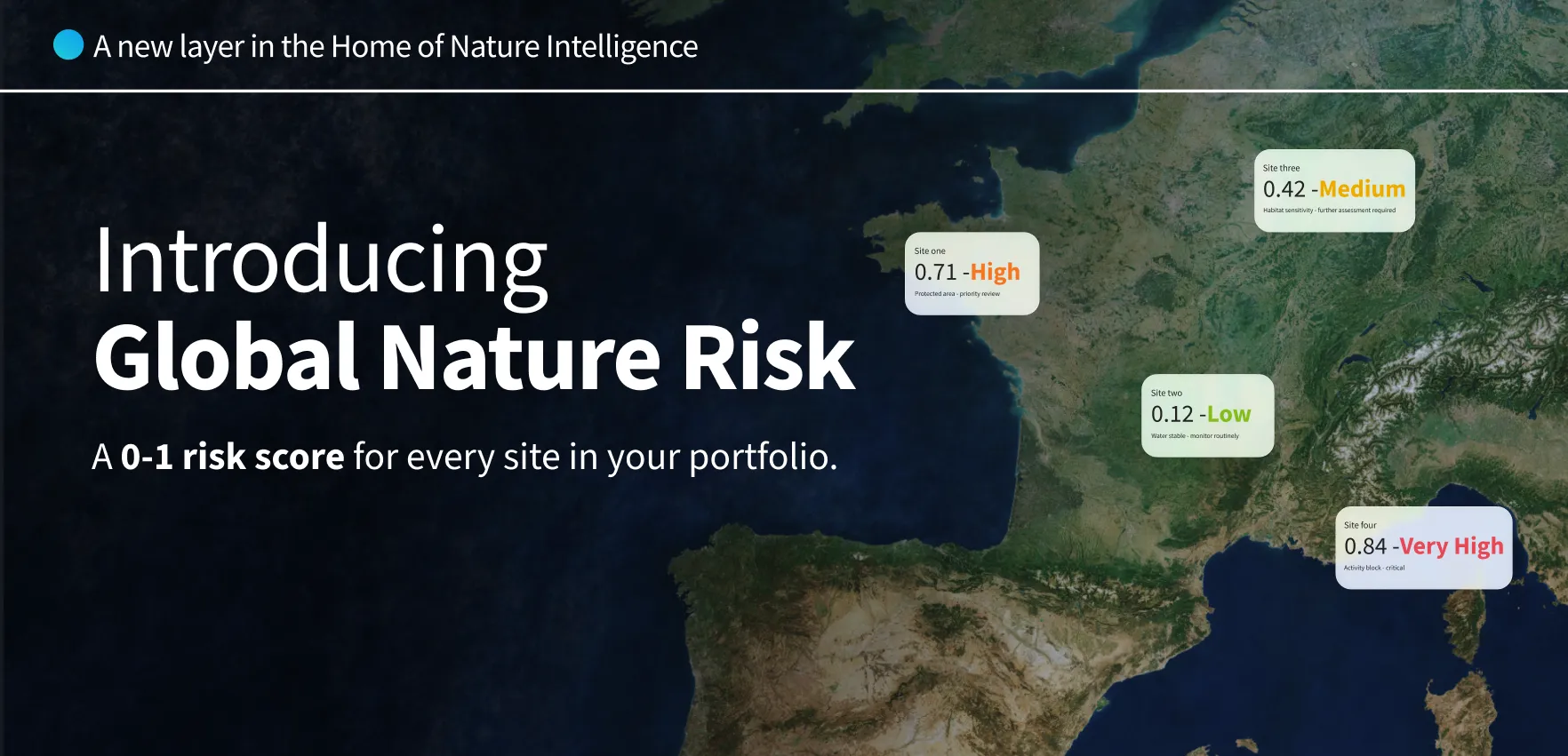
Disclosure frameworks and investors are converging on outcome-based metrics as the only credible means of comparing within and between portfolios of projects, sourcing regions and landscapes. Activity-based metrics cannot inform credit risk valuations, loan underwriting, transition finance or investment theses. Trees planted, hectares conserved, seedlings deployed describe inputs. They do not describe whether the natural capital asset is gaining or losing value.
The harder problem is extracting the full value from the MRV already being done. Forest operators, jurisdictions and financial institutions are spending heavily on monitoring. Satellites, carbon inventories, biodiversity surveys, water quality programmes. Yet most of that investment is built for a single reporting line and cannot be re-asked when a different stakeholder arrives with a different question. An architecture that combines these data stacks solves that. One evidence base, measured once, answers carbon, water and nature questions in parallel, on terms that are comparable across estates, biomes and reporting years.
Composition, Structure and Function measured in parallel deliver the total resilience picture. Underneath each component sits a hierarchy of sub-metrics that rolls up into the resilience signal and, at the same time, answers the specific questions different decision-makers are asking.
The carbon and biomass layer rolls up into the climate regulation signal. Annual biomass trajectory, net carbon flux, and sequestration benchmarked against ecological maximum: these answer IPCC Tier 1 and Tier 2 inventory accounting, voluntary carbon standards (Verra VM0047, ACR), and FLAG reporting in parallel. The same data underpins carbon credit issuance and capital allocation into the management units where sequestration is measurably highest.
The habitat, species and soil layer rolls up into the ecosystem functional integrity signal. Community composition from eDNA, habitat connectivity from geospatial analytics, and soil biological condition certified to the Accounting for Nature framework: these populate the species and habitat disclosures that Kunming-Montreal Target 15, TNFD C5.0, the Nature Positive Initiative, and ESRSE4 require. The same data supports restoration targeting, biodiversity credit issuance, and supplier due diligence under EUDR.
The water layer(catchment integrity, riparian condition, seasonal water balance, biological water quality from aquatic eDNA) rolls up into the water security signal. Forest structure is a direct input here: explicit biomass maps, rather than simple forest or non-forest cover, materially improve the hydrological modelling these metrics rest on. Insurers use the same sub-metrics for catchment risk pricing. Agricultural and fibre buyers use them for sourcing risk. Investors use them to price water-dependent assets.
The resilience signal and the disclosure indicators are extracted from the same underlying dataset.
And because every estate is measured through the same methodology, against the same reference logic, in the same units, outputs are comparable in ways activity-based reporting has never been. Comparable at the project level, scoring a restoration or conservation intervention against reference condition. Comparable at the landscape and sourcing region level, tracking jurisdictional and supply chain trajectory. Comparable between estates inside a single company portfolio, targeting capital where it will deliver measurable recovery. And comparable between company portfolios, so investors, regulators and rating agencies can read the same signal whether they are looking at Brazil, Indonesia or New Zealand, at a forestry operator, a pulp and paper company or a downstream buyer of forest products.
What this means in practice
This is the direction our work is pointed, and the data layers to do it now exist.
NatureMetrics, Chloris Geospatial, and the Antonelli Foundation have been scoping a Forest Ecosystem Condition Index: a certified, peer-reviewed metric that would integrate soil biological health, freshwater ecosystem condition, terrestrial biodiversity, and ecosystem functional integrity into a single, comparable condition score, benchmarked against intact reference forest. The methodology is anchored in the Atlantic Forest of Brazil, one of the most biodiverse and threatened biomes on Earth, and designed to be scaled across tropical, subtropical, and temperate biomes globally.
The architecture combines exactly the data stacks described above: Chloris’s annual30-metre biomass and carbon maps (back cast to 2000) providing continuous, wall-to-wall coverage of the structural and functional layers across every hectare of the estate; NatureMetrics’ geospatial biodiversity analytics(back cast to 2016) for habitat condition and connectivity; and NatureMetrics eDNA from soil, water, and terrestrial samples for the compositional layer that satellites cannot provide, sampled at strategic sites and benchmarked against intact reference ecosystems. The Accounting for Nature-certified Soil Ecosystem Condition Indicator is already operational. The Forest ECI and Freshwater ECI build on that foundation.
The practical implication is that a forest estate can be characterised not just by how much carbon it stores, but by whether its ecosystems are functioning. Are stored area can be scored against reference condition to determine whether it is building a functional ecosystem or just growing trees. A corridor connecting two forest fragments can be assessed for whether it supports ecological movement or is a green line on a map. And all of this can be tracked over time, providing the trajectory data that investors, regulators, and nature-positive commitments require.
The claim that changes the conversation
In Evan’s blog, he argued that companies should be able to say something new: “Our sourcing is verified deforestation-free AND we source from a jurisdiction where forest carbon is increasing.”
We want to extend that.
The company that can say “Our forests are gaining carbon, their ecosystems are ecologically functional, and the catchments they drain are biologically healthy” is making a claim that is qualitatively different from anything the current measurement infrastructure supports. It connects climate performance (carbon trajectory), water security(catchment biological health), and nature outcomes (ecosystem condition) into a single, evidence-based statement.
That is what the climate-water-nature nexus looks like when it is measured, not just diagrammed.
What follows from this
The corporate sustainability conversation is full of nexus thinking and short on nexus measurement. The tools to close that gap now exist. Satellite biomass data provides the carbon trajectory. Geospatial analytics provide the landscape structure. eDNA provides the biological ground truth. Ecosystem condition indicators integrate all three into scores that can be tracked, compared, and disclosed.
The companies and jurisdictions that invest in this measurement architecture now will be the ones that can make credible, verifiable claims about the condition of the natural systems they manage, not just their extent, not just their carbon, but their ecological health. And those are the claims that will matter most as climate, water, and nature frameworks converge.
If you are working on any part of this - corporate forest management, landscape-level carbon accounting, nature-positive strategy, water stewardship, or the measurement infrastructure that connects them - we would be glad to hear from you. Between Chloris and NatureMetrics, we cover the full data stack from satellite to soil. And the conversation about how to use it well is just beginning.
About the authors
Pippa Howard is Chief Nature Strategist at NatureMetrics, where she leads the company’s professional services division and nature strategy practice. She has over 30 years experience in biodiversity conservation, environmental management, and sustainability across the corporate and development sectors, and has been a key architect of nature-positive frameworks for major energy and extractive companies.
Evan Paul is SVP of Solutions at Chloris Geospatial, which provides high-resolution forest biomass and carbon data for corporate, jurisdictional, and landscape-level applications. Chloris data underpins jurisdictional REDD+ submissions, corporate FLAG reporting, and carbon finance across the tropics.
NatureMetrics(naturemetrics.com) and Chloris Geospatial (chloris.earth) are developing integrated nature intelligence solutions that combine satellite-derived carbon and biomass data with eDNA-based biodiversity monitoring and geospatial ecosystem condition analytics.
[1] Bello, C., et al. (2015). Defaunation affects carbon storage in tropical forests. Science Advances, 1(11), e1501105. https://doi.org/10.1126/sciadv.1501105. The effect has since been corroborated beyond the Atlantic Forest: Osuri, A. M., et al. (2016). Contrasting effects of defaunation on aboveground carbon storage across the global tropics. Nature Communications, 7, 11351.https://doi.org/10.1038/ncomms11351.


.jpg)

.jpg)